Navigation and communication in ships have been integral to the maritime industry for centuries, evolving with technological advancements. From the early era of sailing, sailors relied on observing stars and planets to navigate their course through the vast oceans.
Transitioning to today, ship officers now have access to robust electronic instruments and sophisticated onboard equipment. These advanced systems provide crucial data on several navigation parameters, including the ship’s course and speed, in addition to detecting other ships or nearby objects.
A modern ship typically has several types of navigation and communication equipment. However, it’s important to note that the equipment utilized can vary depending on the ship’s type and size.
History of Navigation and Communication in Ships
Throughout history, advancements in navigation systems have played a significant role in improving maritime safety and efficiency. The 15th century marked a turning point with the adoption of the magnetic compass in Europe, providing a reliable means to determine direction.
Over time, the development of celestial navigation techniques empowered sailors to determine their location using stars and other celestial entities.
For maritime communication systems, early methods utilized basic visual signals like smoke and signal flags. However, with the invention of the telegraph, ships acquired the ability to communicate with shore stations, enabling faster and more streamlined exchange of information. The introduction of wireless telegraphy further revolutionized communication at sea, enabling ships to communicate wirelessly.
Two notable entities, the International Telecommunication Union (ITU) and the International Maritime Organization (IMO), have significantly contributed to the development of onboard communication and navigation systems.
The IMO is responsible for regulating and improving safety protocols in maritime transportation, including formulating international regulations. Conversely, the ITU, a subsidiary of the United Nations, is focused on telecommunications and information and communication technologies.
The ITU has formulated guidelines and standards for efficient, reliable maritime communication across various frequency bands, like HF, MF, and VHF. Concurrently, the IMO has collaborated with the ITU to deploy communication systems in the maritime industry, facilitating communication between ships and from ship to shore.
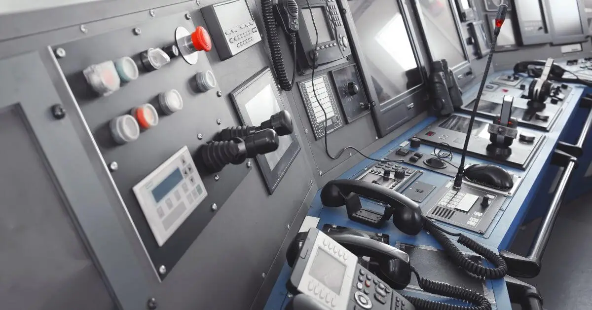
Navigation Equipment
Radar

‘Radar’ is an acronym for ‘Radio Detection and Ranging.’ A radar is a rotating antenna that sends signals and collects information about the presence of objects (ships, boats, formations due to weather conditions, terrain, etc.) surrounding the ship.
The Radar describes the ship’s distance from such objects and helps avoid collisions. There is more than one type of Radar, and the classification depends on the frequency at which they operate. The major uses of a Radar are:
- Determining the vessel’s position, utilizing earthly objects such as lighthouses.
- Detect the location and distance of the identified object and determine speed, course, etc.
- Preventing a collision with other objects, such as ships and other watercrafts.
ECDIS (Electronic Chart Display and Information System)

This electronic navigation system displays digital charts and navigation information on its screen and is a very helpful alternative to paper charts.
The ECDIS uses the GPS (Global Positioning System) features to display the ship’s navigational point (location) accurately and helps the ship’s navigators.
ARPA (Automatic Radar Plotting Aid)

ARPA is the computerized added feature to the RADAR, and it takes the information of the course and speed of its ship and monitors the target’s speed and course to calculate the collision avoidance data. It uses the data to plot the safe passage of its ship with the other objects/ships.
ATA (Automatic Tracking Aid)
The ATA allows the navigator to track the targets (up to 10 numbers) using RADAR contacts.
The system can calculate the CPA (Closest Point Approach) and TCPA (Time to CPA) and triggers an audible alarm when the targets being tracked are within the set parameters (time or range).
Autopilot

Autopilot is the technically advanced system used in modern ships, and it takes control of the ship’s steering mechanism, automatically controls the ship, and maintains its predetermined course. It is synchronized with the ship’s gyrocompass and ECDIS.
AIS (Automatic Identification System)

The AIS is a transponder with the designed and built-in capability of automatically providing position, identification, and other relevant information about its ship to other ships and coastal authorities.
The information is displayed on the AIS station or ECDIS. The main purpose of AIS is the safety of navigation and the avoidance of collisions.
Magnetic Compass

The magnetic compass is a reliable and safe navigation tool that helps establish direction on the earth’s surface using a magnetic pointer. The magnetized needle consistently points towards the North Pole, making navigation easy on sea.
Gyrocompass

The gyrocompass is a modern navigation device that relies on a spinning wheel (gyroscope) to maintain its orientation towards the true north pole. Unlike traditional compasses, it eliminates magnetic disturbances, offering high accuracy and reliability.
Rudder Angle Indicator (RAI)

A rudder angle indicator is a device normally placed near the ship’s wheel on the bridge and in the engine control room, and it is used to indicate the current position of the rudder blade. The RAI works in coordination with the rudder angle transmitter.
Speed and Distance Log Device
This is an electronic instrument that measures the surface speed of the ship. The surface speed is determined by taking the reference of the water flowing by the hull (called water reference speed) or to the seabed (called ground reference speed), and this is required by SOLAS (International Convention for the Safety of Life at Sea).
VDR (Voyage Data Recorder)

VDR is similar to the black box in an aircraft. And it is designed for collecting ship voyage data from different sensors onboard a ship. Currently, all passenger ships and high-tonnage other ships must carry VDR. A VDR helps the investigators in case of untoward accidents.
Echo Sounder

An echo sounder is a transducer normally located at the bottom of the ship (below the hull), sending the sound wave pulses. The sound pulses travel through the depth of water, hit the objects below (ocean beds, shipwrecks, etc.), and bounce back to reach the transducer.
From this, the echo sounder calculates the distance between the ship’s bottom and the object directly below it.
ROTI (Rate Of Turn Indicator)
The ROTI on board a ship reveals the rate a ship turns in terms of degrees per minute (°/minute). This is a very important instrument for the crew managing the ship. The ROTI can be used to turn the ship at a stable turn rate. The principle of the working of ROTI is similar to the working of a gyroscope.
GPS (Global Positioning System)
GPS is a satellite navigational system that enables to establish the precise location of objects. Initially, GPS was created for the military; however, today, it is used by everybody.
Using GPS, the ship’s position, speed, course, and time can be established and used to define the distance between two objects. The GPS information is reproduced by other equipment on the ship bridge, such as RADAR and ECDIS.
Anemometer

An anemometer (or anemoscope) is a measuring equipment installed on a ship to measure and digitally display the relative speed and direction of the wind blowing above the moving ship. This data is very important for the ship’s navigation. The anemometer can also measure other weather parameters like temperature.
Interesting Article: What are the Main Parts of Ships?
Equipment Used for Communication
GMDSS (Global Maritime Distress and Safety System)

GMDSS stands for a worldwide network of automated emergency communications for ships and vessels at sea. All ships of 300 tonnages and above must carry radio equipment conforming to international standards.
The main reason for GMDSS is to ensure that the ships complying with international standards and will never face the situation of unanswered distress calls. And that there will be a definite response to emergencies.
GMDSS includes several systems to perform various communication functions, such as communication of ship-to-shore distress alerts, shore-to-ship distress alerts, communication of distress alerts between ships, safety alerts, etc.
Digital Selective Calling

Digital selective calling (DSC) is a standardized method of transmitting and receiving distress signals, routine between ships and ship to shore calls over medium-frequency (MF), high-frequency (HF), and very-high-frequency (VHF) maritime radio systems.
DSC developed digitally remote control commands to transmit or receive distress alerts, urgent or safety calls, or periodic priority messages. It is a core part of the Global Maritime Distress Safety System (GMDSS).
Today, DSC controllers are often integrated with the VHF radio under SOLAS.
LRIT (Long Range Identification and Tracking)
The LRIT system enables global identification and tracking of ships, increasing shipping security and promoting marine safety and environmental protection. Every individual ship commits to transmitting LRIT data, aligning with the SOLAS convention’s framework.
BNWAS (Bridge Navigational Watch Alarm System)
The BNWAS system is designed to ensure the safety of navigation by alerting in case the watch officer on the bridge falls asleep or becomes incapacitated. Its purpose is to monitor bridge activity and prevent accidents through timely alarm activation.
How does BNWAS work? At regular intervals, the watch officer needs to press a button to reset the alarm or operate navigation equipment. Failure to do so will trigger the BNWAS to sound an alarm at the end of the set interval.
SART (Search And Rescue Transponder)

SART is a vital tool for Search and Rescue operations. This device is designed to assist in pinpointing the location of distressed vessels or individuals. It’s an electronic device onboard the vessel that operates in multiple frequencies. The SART can be a radar-SART or a GPS-based AIS (Automatic Identification System) SART.
When activated, SART’s radar signal appears on the rescuer’s radar display, making locating the vessel or individual in distress easier. SART is an essential tool that provides great aid during emergencies, increasing the chances of a successful rescue operation.
NAVTEX (Navigational Telex)

NAVTEX is a part of GMDSS (Global Maritime Distress Safety System). It is the main mode of transmitting urgent marine safety information to ships, including navigational, meteorological warnings and forecasts, and other information of importance.
NAVTEX is an international automated medium frequency (518 kHz) direct-printing service.
VSAT (Very Small Aperture Terminal)

VSAT is a small two-way telecommunication earth station capable of transmitting and receiving real-time satellite data. The size of the VSAT is less than three meters in height. And it can narrow and broadband data via satellites in orbit in real-time.
The availability of VSAT on board a ship helps the ship crew to use a high-speed steady internet connection for fast communication and data exchange.
VHF (Very High Frequency) Radio

Marine VHF radio is a worldwide two-way radio transceiver system on board ships. And it is used for two-way communication between two ships and ship-to-shore communication. And in some cases, a ship and an aircraft.
It operates on FM channels in the VHF radio band (frequency range 156 to 174 MHz). VHF radio is reliable for many communication purposes, including search and rescue. Marine VHF radio equipment is set up on all ships, small and big.
UHF (Ultra High Frequency) Radio

Marine UHF operates on frequencies between 300 MHz and 3 GHz for voice communications between the different sections of the ship. UHF radio allows real-time communication between two or more radios on the ship.
UHF frequencies prorogate well inside the metal structures; hence, it works in a ship. These are walkie-talkie radios.
Sound Reception System
The sound reception system is acoustical navigational support, facilitating the ship’s crew to hear audio signals outside the ship’s enclosed bridge. This system is set up to alert the crew to look out. And is as stipulated by international regulations for preventing collisions at sea.
The sound output levels of the system are controlled by the whistle system and PAGA (Public Address and General Alarm) system.
Ship’s Bell

The ship’s bell is made from bronze or brass and has the ship’s name on it. Traditionally, it was used for indicating the time and other customary functions. In earlier days, the bell was also used to warn other nearby ships during poor visibility or darkness.
However, today, the presence of the ship’s bell in a ship is more or less ceremonial. Since clocks, ship horns, and other gadgets have taken over its functions.
Ship’s Gong
A ship’s gong is made of brass or bronze. It is a round object that makes a high-pitched sound when struck by metal. Traditionally, in an anchored ship, the sound of the ship’s bell in the forepart of the ship is followed by the sound of the ship’s gong in the aft part. The gong is normally held in one hand and struck with metal using the other hand.
Like the ship’s bell, in a modern ship, the function of the gong is taken over by the ship’s horn and whistles.
Ship’s Whistle (Horn)

A ship’s whistle or horn is an electronically induced sounding and signaling device normally used for maneuvering, warning, and alert signals during limited visibility (fog). For this reason, the whistle is also termed a fog whistle.
The COLREG (Convention on the International Regulations for Preventing Collisions at Sea) stipulates the ship’s whistle’s specifications and positioning based on the ship’s size and type.
ALDIS Lamp (Daylight Signaling Lamp)

The ALDIS lamp is named after its inventor Arthur Cyril Webb Aldis, and during the olden days, it was used for exchanging Morse code messages between ships. The optical Morse code signals were exchanged visually in ship-to-ship communication.
The present-day ALDIS lamp is a focus lamp that can produce a pulse of light normally using the Morse code pattern. Modern ships do not use ALDIS lamps for regular communication between ships. Still, every ship has them as a backup device in case another means of radio communication fails.
Navigational Lights

The purpose of navigational lights in a ship is to keep the ship safe and prevent collisions during the darkness of night or poor visibility. The navigational lights are coloured electric lights on the mast of the ship and indicate the direction of the ship’s movement and its condition (moving or anchored).
The navigational lights on one ship are seen and understood by the crew of the other nearby ships.
Maritime Signal Flags

International maritime signal flags are different flags with a unique pattern of colors, and they are used for communication with other ships. The code system is the International Code of Signals.
Maritime signal flags consist of 26 square flags. Each representing one letter of the English alphabet, 10 numbered pendants, one answering pendant, and three substitutes. All these flags and pendants are made using five colors for easy and simple recognition.
A series of flags or one individual flag on a ship can convey the standard coded meaning to the other ships nearby. Due to the availability of modern communication, the utility of the signal flags is limited to emergencies.
Conclusion
We have explored the significant advancements in navigation equipment and marine communication systems in ships. From early reliance on celestial bodies to today’s state-of-the-art electronic instruments and sophisticated bridge equipment.
These modern systems provide ship officers with accurate and reliable information on various aspects of their journey. Such as the ship’s course, speed, and nearby vessels or objects.
We hope you found this article informative and engaging. Contributing to a deeper understanding of these equipment’s critical roles in enhancing the safety and efficiency of shipping operations.